DARIAH liefert eine überaus praxisnahe und nützliche Zusammenstellung von Lizenzmodellen zu Forschungsdaten. Die Quellengrundlage von Veröffentlichungen sollte/muss mindestens 10 Jahre vorgehalten werden. Was letztlich bedeutet, dass die Rohdaten idealerweise nicht nur irgendwo abgelegt werden, sondern möglichst einfach zugänglich gemacht werden. Damit werden die eigenen Erkenntnis nachvollziehbar und überprüfbar, aber auch eine Nachnutzung in neuem Kontext ermöglicht. Die Veröffentlichung von Daten im Internet ist ein heikles Geschäft, wobei http://forschungslizenzen.de/ eine große Hilfe sein kann. Danke an Philipp Franck für den Tipp!
Digital Humanities Workshop am AOI, Zürich, am 18.1./19.1.2019
heiMAP-Workshop zu Digital Humanities mit Schwerpunkt Raum im Rahmen des interdisziplinären Doktoratsprogramm Asien und Europa des Asien-Orient-Instituts der Universität Zürich mit Milena Guthörl, Lukas Loos, Philipp Franck und Kilian Schultes. Vielen Dank für die Einladung!
heiMAP im HGIS Club am 20.11.2018
Mohammed Rizwan Khan war zu Besuch im HGIS Club in der Sitzung am 20.11.2018 und führte in die Geokomponenten von heiMAP ein. Vielen Dank für alle Informationen und Erklärungen sowie für die Diskussion der Features mit den Historikern/innen!
Dr. Wolfgang Moschek created a small WebMap of all participants of the „GIS and the City„-conference in Darmstadt with links to their (H)GIS projects: https://arcg.is/1CyXCm. Thanks!
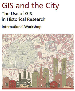
Dr. Mohammed Zia aus der Geoinformatik & Dirk Eller aus der Landesgeschichte werden heiMAP auf dem Workshop „GIS and the City. The Use of GIS in Historical Research“, 13.-14.9.2018 in Darmstadt, präsentieren.
„The History of Cartography“ online
Weihnachten im August! Vier Bände der „The History of Cartography“ (Vorgeschichte bis Renaissance, 20 Jahrhundert) wurden von der University of Chicago zum freien Download als pdf in sehr guter Qualität ins Netz gestellt: https://www.press.uchicago.edu/books/HOC/index.html
Weitere Informationen via „Open Culture„.
- Harley, John Brian/Woodward, David (Hgg.): Cartography in Prehistoric, Ancient, and Medieval Europe and the Mediterranean [ebook] (The History of Cartography 1), Chicago, Ill. 1987.
- Harley, John Brian/Woodward, David (Hgg.): Cartography in the Traditional Islamic and South Asian Societies (The History of Cartography 2.1), Chicago, Ill. 1992.
- Harley, John Brian/Woodward, David (Hgg.): Cartography in the Traditional East and Southeast Asian Societies (The History of Cartography 2.2), Chicago, Ill. 1994.
- Woodward, David/Lewis, G. Malcolm (Hgg.): Cartography in the Traditional African, American, Arctic, Australian, and Pacific Societies (The History of Cartography 2.3), Chicago, Ill. 1998.
- Woodward, David (Hrsg.): Cartography in the European Renaissance. Two Volumes (The History of Cartography 3).
- Monmonier, Mark S. (Hrsg.): Cartography in the Twentieth Century. Two Volumes (The History of Cartography 6), Chicago, Ill. 2015.
Tagesaktuelle Satellitenaufnahmen der ganzen Welt bei Project Planet
Online verfügbare Satellitenaufnahmen, beispielsweise bei Google Maps/Earth, sind üblicherweise Monate, wenn nicht sogar Jahre alt und damit in der schnellebigen modernen Gesellschaft gelegentlich durchaus problematisch. Project Planet hat es sich zum Ziel gesetzt, tagesaktuelle hochaufgelöste Satellitenbilder des gesamten Globus zu sammeln – ein Ziel, das seit nun gut einem Jahr mithilfe einer Flotte von über 200 Satelliten durchgängig erreicht wird. Dadurch wird es möglich, Veränderungen in Natur- wie Kulturlandschaft detailliert nachzuverfolgen. Ein Beispiel hierfür wäre die seit Anfang 2018 andauernde Eruption des Kilauea auf Hawaii, bei der das Vordringen der massiven Lavaströme inklusive Bildung neuen Landes gut sichtbar ist, doch auch die Auswirkungen des sehr trockenen Sommers in Deutschland auf Wälder und Wiesen sind klar zu erkennen.
https://www.planet.com/
Noch relativ neu und momentan in der Betaphase befindlich ist eine Weiterentwicklung, Planet Analytics. In diesem nächsten Schritt sollen unter Community-Mithilfe Bilderkennungs-Algorithmen entwickelt und verbessert werden, durch die der massive Datenbestand von Planet durchsuchbar und für Analysen fruchtbar wird. Ziel ist eine automatische Erkennung von Gebäuden, Flugzeugen oder Schiffen. Die Anwendungsmöglichkeiten für diese Daten reichen von der Verbrechensbekämpfung (Schmugglerschiffe) über Verkehrsplanung und Wirtschaftswissenschaften bis zur Katastrophen- und Flüchtlingshilfe.
Einen Einblick bietet dieser kurze TED Talk:
https://www.youtube.com/watch?v=IQkj4CF_ha4
Ein Test-Zugriff auf die Daten von Planet ist über einen kostenlosen 14-tägigen Trial-Account möglich. Außerdem können sich Studenten und Wissenschaftler für einen kostenlosen Zugriff mit monatlich begrenzter Datenmenge bewerben, und für Forschungsprojekte und Institute stehen mehrere kostenpflichtige Lizenzen zur Auswahl.
Dirk Eller im Team heiMAP
Dirk Eller vertritt in unserem interdisziplinären Projekt heiMAP unter den Projektmitarbeitern/innen die Landesgeschichte. Er arbeitet basierend auf den Erfahrungen aus den eigenen Projekten des HGIS Clubs wie auch der von uns beratenen Unternehmungen an Best-Practice-Tutorials für neue Nutzer/innen auf heiMAP. Diese zielen vor allem darauf ab, die vielfach vergleichsweise it-fernen Geisteswissenschaftler/innen zu unterstützen, die HGIS als neue Methode austesten und/oder die digitalen Ressourcen von heiMAP sichten und nutzen möchten. Weiterhin bringt Dirk Eller seine in vielen Jahren der Projektarbeit gewonnene Expertise ein, um zum einen das Metadatenmodell im Dialog mit den Projektpartnern an den Bedürfnissen der Geisteswissenschaften auszurichten und zum anderen Workflows aus der Praxis in die Entwicklung unserer kollaborativen virtuellen Forschungsumgebung einzubringen.

Dirk Ellers Dissertationsprojekt unter dem Titel „Die Kurpfalz auf dem Kartentisch. (Re)Präsentationen von Herrschaft auf spätmittelalterlichen und frühneuzeitlichen Karten“ nutzt historische Karten als Quellen, und zwar nicht vornehmlich zu „tatsächlichen“ Veränderungen in Landschaft und Bebauung, sondern zur Darstellung und Selbstdarstellung eines bedeutenden Fürstentums im Heiligen Römischen Reich. Karten sind nicht „nur“ Orientierungshilfe und Informationsquelle, sie formen auch in erheblichem Maße Raumvorstellungen und Mental Maps ihrer Betrachter – da sie zumindest theoretisch nur die echte Welt wiedergeben sollen, ist es leicht alle ihre Inhalte unkritisch für bare Münze zu nehmen. Gleichzeitig jedoch ist die Produktion einer Karte ein höchst aufwendiges Verfahren, bei dem der Kartograph im Rahmen der verschiedenen Prozesse der Generalisierung signifikante Gestaltungsspielräume hat und diese nutzen muss, aber auch zahlreichen Beschränkungen und äußeren Einflüssen unterliegt. Karten können also nicht nur Informationen zu den in ihnen dargestellten Gegenden liefern, sondern bei vorsichtiger quellenkritischer Verwendung auch als Fenster in die Köpfe und Vorstellungswelten ihrer Produzenten und Konsumenten dienen.
Vor diesem Hintergrund soll in der Dissertation untersucht werden, wie die Kurpfalz als Herrschaftsgebiet in Karten vom Spätmittelalter bis zum Reichsdeputationshauptschluss (und damit dem Ende der eigenständigen Kurpfalz) dargestellt wurde. Es sollen Erkenntnisse sowohl zum Selbstverständnis der Kurpfalz und ihrer Bewohner als auch zur Außendarstellung sowie externen Wahrnehmung gewonnen werden, indem jede Karte in ihrem Entstehungskontext betrachtet wird: Woher stammt die Karte, woher der Kartograph? Woher bezog er seine Informationen, wie gut und vollständig waren diese? In welchem politischen Kontext entstand die Karte? Wie wurde sie verbreitet, wer nutzte sie? Diese und ähnliche Fragen müssen bei der Interpretation einer Karte als historische Quelle berücksichtigt werden, da sie sowohl Einfluss auf ihr letztendliches Erscheinungsbild als auch auf ihre Wirkung haben.
Dabei werden sowohl längerfristige Entwicklungsprozesse im Kontext benachbarter Territorien als auch konkrete Fallbeispiele in den Blick genommen. Beispielsweise wird untersucht, wie die Verlagerung der kurfürstlichen Residenz von Heidelberg zunächst nach Mannheim und später nach München sich auf die kartographische Darstellung der betroffenen Städte auswirkte, zum Beispiel auf ihre Bedeutung und visuelle Prominenz im Kontext der umgebenden Städte.
Orbis Latinus Online – Relaunch 2018
Unser Gazetteer „Orbis Latinus Online“ (OLO) für Lateinisch-Deutsche Ortsnamen ist nun dank des Einsatzes von Nemo Grippa in voller Funktionalität im Rahmen des Projekts heiMAP wieder online: http://hgis.club/orbis-latinus-online
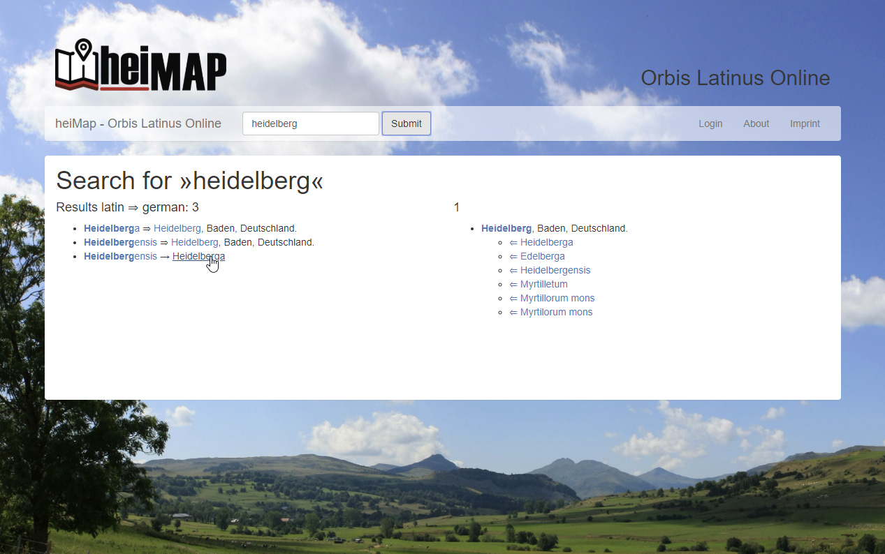
Alternative Vorschläge zur Lokalisierung werden auf einer Karte angezeigt und können wieder online editiert werden. Wer mitmachen möchte, der/die kann sich gerne bei uns melden (olo[at]hgis.club). Der besseren Reichweite wegen haben wir die Oberfläche auf Englisch umgestellt. An der Anbindung an geoTWAIN wird gearbeitet. Herzlichen Dank an Philipp Franck für alle Unterstützung!
GIS and the City
The Use of GIS in Historical Research
International Workshop, September 13th and 14th 2018
Technical University of Darmstadt, Germany
The general use of digital maps and mapping has increased dramatically over the last years. Parallel to this boom in mapping the diffusion of Geographic Information Systems (GIS) rose with the ubiquitous use of digital data, devices and the internet. Maps and map-based information are not only everyday companions on our cell-phones, weather and traffic maps, they also move more and more into the focus of the Humanities. GIS seems particularly attractive for historical research with a strong spatial dimension such as Urban History. GIS has been applied not only for visualizing patterns and structures which have already been analysed by ‘traditional’ methods, but also for the process of building and developing hypotheses through the identification of spatial structures which are not so easily discerned in narrative or tabular form.
This Workshop An European-wide setting of interesting and different approaches in the use of GIS for historical questions and research is presented in this workshop. A “GIS Marketplace” will offer new ideas and projects from students and scholars working with GIS & History. A concluding Round-Table discussion will present critical views on benefits and possible pitfalls of GIS in the Humanities.